Ans night lights from space
Night Light of Ans (Wallonia) from space (Belgium) Src. Average luminocity for 10x10km area is 80.8516% and for 50x50km: 27.9572%.
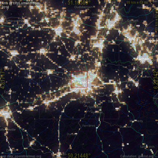
Analysis of Ans night lights 2016
Square area 10x10 km:
100  28.48%
90-99 29.01%
80-89 8.02%
70-79 6.82%
60-69 7.35%
50-59 3.74%
40-49 2.54%
30-39 7.89%
20-29 5.75%
10-19 0.4%
0-9 0%
28.48%90-99
29.01%80-89
8.02%70-79
6.82%60-69
7.35%50-59
3.74%40-49
2.54%30-39
7.89%20-29
5.75%10-19
0.4%0-9
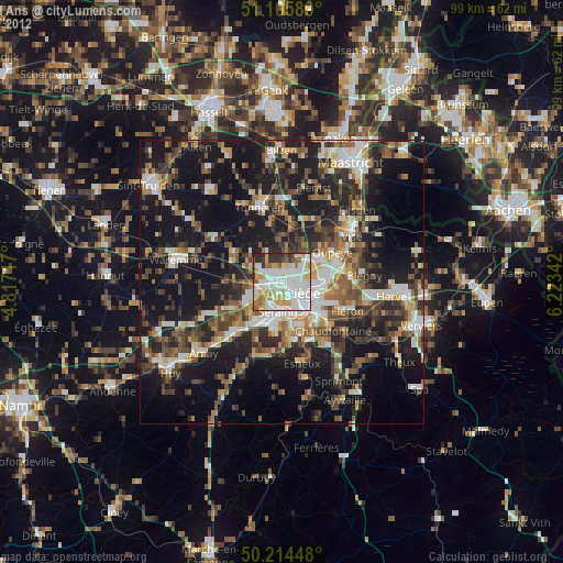
0%Square area 50x50 km:
100 4.57%
90-99 5.33%
80-89 2.2%
70-79 2.34%
60-69 3.42%
50-59 4.13%
40-49 4.15%
30-39 4.41%
20-29 9.2%
10-19 24.04%
0-9 36.23%
4.57%90-99
5.33%80-89
2.2%70-79
2.34%60-69
3.42%50-59
4.13%40-49
4.15%30-39
4.41%20-29
9.2%10-19
24.04%0-9
36.23%Clear (daylight) street map image can be seen on geolist.org.
Map coordinates:
51° 6' 21.2" North, 4° 49' 1.8" East
50° 39' 44.3" North, 5° 31' 13" East
50° 12' 52.1" North, 6° 13' 24.3" East
Some cities around Ans sort by population:
• Liège
4.6 km =2.9 mi,  133°
133°
• Seraing
8.9 km =5.5 mi,  188°
188°
• Herstal
7.3 km =4.5 mi,  88°
88°
• Flémalle-Haute
8.7 km =5.4 mi,  217°
217°
• Oupeye
10.5 km =6.5 mi,  58°
58°
• Saint-Nicolas
3.9 km =2.4 mi,  167°
167°
• Awans
4.1 km =2.5 mi,  278°
278°
• Juprelle
5.1 km =3.2 mi,  8°
8°
2803160 (p: 27,297)
Sources (retrieved 2019-11-25):
» Earth at Night: Flat Maps 2012, 2016