Srebrenik night lights from space
Night Light of Srebrenik (Federation of B&H) from space (Bosnia and Herzegovina) Src. Average luminocity for 10x10km area is 5.7091% and for 50x50km: 4.6463%.
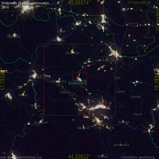
Analysis of Srebrenik night lights 2016
Square area 10x10 km:
 0.3%
0.3%90-99
0.91%80-89
1.06%70-79
0.76%60-69
0.61%50-59
0.61%40-49
1.21%30-39
0.61%20-29
1.82%10-19
0.91%0-9
91.21%Square area 50x50 km:
0.38%90-99
0.53%80-89
0.26%70-79
0.46%60-69
0.6%50-59
0.91%40-49
0.9%30-39
0.74%20-29
1.32%10-19
5.21%0-9
88.69%Clear (daylight) street map image can be seen on geolist.org.
Map coordinates:
45° 12' 20.7" North, 17° 47' 6.8" East
44° 42' 29.5" North, 18° 29' 18" East
44° 12' 22.8" North, 19° 11' 29.3" East
Some cities around Srebrenik sort by population:
• Tuzla
23.6 km =14.7 mi,  143°
143°
• Brčko
31.1 km =19.3 mi,  54°
54°
• Doboj
31.8 km =19.8 mi,  274°
274°
• Gračanica
14.1 km =8.8 mi, 267°
• Gradačac
19.5 km =12.1 mi,  345°
345°
• Živinice
31.5 km =19.6 mi,  156°
156°
• Mionica
17.7 km =11 mi, 354°
• Orahovica Donja
11.2 km =7 mi,  237°
237°
3190158 (p: 6,723)
Sources (retrieved 2019-11-25):
» Earth at Night: Flat Maps 2012, 2016