Orahovica Donja night lights from space
Night Light of Orahovica Donja (Federation of B&H) from space (Bosnia and Herzegovina) Src. Average luminocity for 10x10km area is 0.7227% and for 50x50km: 4.4987%.
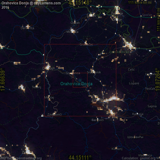
Analysis of Orahovica Donja night lights 2016
Square area 10x10 km:
 0%
0%90-99
0%80-89
0%70-79
0%60-69
0.3%50-59
0%40-49
0.45%30-39
0.15%20-29
0%10-19
0.61%0-9
98.48%Square area 50x50 km:
0.41%90-99
0.55%80-89
0.21%70-79
0.37%60-69
0.65%50-59
0.83%40-49
1.12%30-39
0.74%20-29
1.1%10-19
4.5%0-9
89.52%Clear (daylight) street map image can be seen on geolist.org.
Map coordinates:
45° 9' 5.3" North, 17° 39' 59" East
44° 39' 12.4" North, 18° 22' 10.2" East
44° 9' 4" North, 19° 4' 21.5" East
Some cities around Orahovica Donja sort by population:
• Tuzla
26.8 km =16.7 mi,  118°
118°
• Doboj
24 km =14.9 mi,  291°
291°
• Gračanica
7.2 km =4.5 mi,  319°
319°
• Gradačac
25.4 km =15.8 mi,  10°
10°
• Mionica
24.9 km =15.5 mi,  17°
17°
• Maglaj
24.4 km =15.2 mi,  241°
241°
• Srebrenik
11.2 km =7 mi,  57°
57°
• Kovači
26.2 km =16.3 mi,  209°
209°
3194061 (p: 5,612)
Sources (retrieved 2019-11-25):
» Earth at Night: Flat Maps 2012, 2016