Çinarlı night lights from space
Night Light of Çinarlı (Qǝx) from space (Azerbaijan) Src. Average luminocity for 10x10km area is 1.7585% and for 50x50km: 0.3699%.
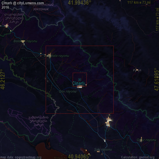
Analysis of Çinarlı night lights 2016
Square area 10x10 km:
 0%
0%90-99
0.34%80-89
0%70-79
0%60-69
0.17%50-59
0.85%40-49
0.34%30-39
0%20-29
0.85%10-19
0.17%0-9
97.28%Square area 50x50 km:
0.03%90-99
0.06%80-89
0.02%70-79
0%60-69
0.05%50-59
0.11%40-49
0.1%30-39
0.1%20-29
0.14%10-19
0.07%0-9
99.33%Clear (daylight) street map image can be seen on geolist.org.
Map coordinates:
41° 59' 39.7" North, 46° 12' 45.7" East
41° 28' 10.7" North, 46° 54' 57" East
40° 56' 26.3" North, 47° 37' 8.2" East
Some cities around Çinarlı sort by population:
• Sheki
37.5 km =23.3 mi,  145°
145°
• Zaqatala
28.9 km =18 mi,  308°
308°
• Akhty, RU
67.9 km =42.2 mi,  90°
90°
• Qax
5.7 km =3.5 mi,  176°
176°
• Belokany
51.2 km =31.8 mi,  303°
303°
• Aliabad
23.5 km =14.6 mi,  273°
273°
• Oğuz
63.8 km =39.6 mi,  133°
133°
• Lagodekhi, GE
66.3 km =41.2 mi, 306°
586845 (p: 6,508)
Sources (retrieved 2019-11-25):
» Earth at Night: Flat Maps 2012, 2016