Oğuz night lights from space
Night Light of Oğuz from space (Azerbaijan) Src. Average luminocity for 10x10km area is 1.6429% and for 50x50km: 0.508%.
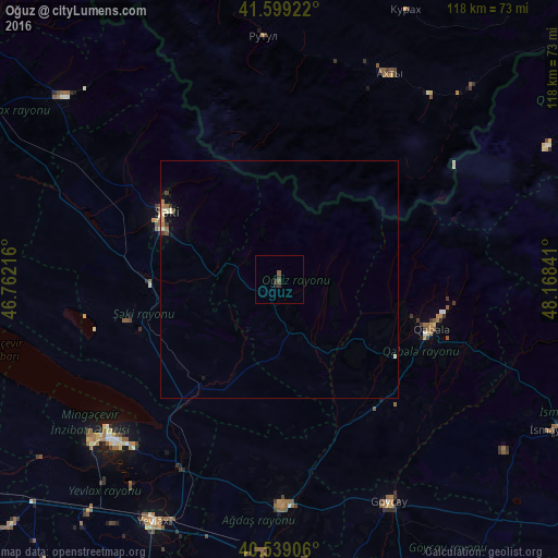
Analysis of Oğuz night lights 2016
Square area 10x10 km:
 0%
0%90-99
0%80-89
0%70-79
0%60-69
0%50-59
1.14%40-49
0.32%30-39
1.3%20-29
1.14%10-19
0%0-9
96.1%Square area 50x50 km:
0%90-99
0.12%80-89
0.06%70-79
0.03%60-69
0.06%50-59
0.17%40-49
0.08%30-39
0.13%20-29
0.06%10-19
0.06%0-9
99.23%Clear (daylight) street map image can be seen on geolist.org.
Map coordinates:
41° 35' 57.2" North, 46° 45' 43.8" East
41° 4' 16.6" North, 47° 27' 55" East
40° 32' 20.6" North, 48° 10' 6.3" East
Some cities around Oğuz sort by population:
• Yevlakh
56.9 km =35.4 mi,  207°
207°
• Mingelchaur
48.3 km =30 mi,  224°
224°
• Sheki
28.1 km =17.5 mi,  298°
298°
• Geoktschai
52.3 km =32.5 mi,  153°
153°
• Ağdaş
47.2 km =29.3 mi,  179°
179°
• Akhty, RU
48.6 km =30.2 mi,  27°
27°
• Qutqashen
33.7 km =20.9 mi,  107°
107°
• Kurush, RU
38.9 km =24.2 mi,  52°
52°
585333 (p: 6,600)
Sources (retrieved 2019-11-25):
» Earth at Night: Flat Maps 2012, 2016