Wyndham Vale night lights from space
Night Light of Wyndham Vale (Victoria) from space (Australia) Src. Average luminocity for 10x10km area is 38.4545% and for 50x50km: 22.1413%.

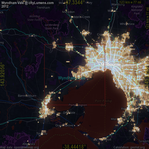
Analysis of Wyndham Vale night lights 2016
Square area 10x10 km:
 3.57%
3.57%90-99
4.22%80-89
5.03%70-79
7.47%60-69
10.06%50-59
8.93%40-49
6.01%30-39
2.76%20-29
10.55%10-19
17.86%0-9
23.54%Square area 50x50 km:
5.64%90-99
5.41%80-89
2.29%70-79
3.26%60-69
2.78%50-59
2.07%40-49
1.8%30-39
1.8%20-29
3.49%10-19
6.78%0-9
64.69%Clear (daylight) street map image can be seen on geolist.org.
Map coordinates:
37° 20' 3.8" South, 143° 55' 14" East
37° 53' 29" South, 144° 37' 25.2" East
38° 26' 39" South, 145° 19' 36.5" East
Some cities around Wyndham Vale sort by population:
• Point Cook
11.5 km =7.1 mi,  103°
103°
• Werribee
3.9 km =2.4 mi, 104°
• Hoppers Crossing
6.8 km =4.2 mi,  81°
81°
• Tarneit
6.9 km =4.3 mi,  27°
27°
• Truganina
13.9 km =8.6 mi,  53°
53°
• Williams Landing
11 km =6.8 mi,  72°
72°
• Seabrook
11.9 km =7.4 mi, 84°
• Laverton
13.2 km =8.2 mi, 75°
8348078 (p: 23,093)
Sources (retrieved 2019-11-25):
» Earth at Night: Flat Maps 2012, 2016