Wentworthville night lights from space
Night Light of Wentworthville (New South Wales) from space (Australia) Src. Average luminocity for 10x10km area is 93.2797% and for 50x50km: 55.8639%.
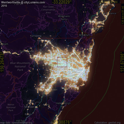
Analysis of Wentworthville night lights 2016
Square area 10x10 km:
 33.74%
90-99
37.59%80-89
18.18%70-79
10.31%60-69
0.17%50-59
0%40-49
0%30-39
0%20-29
0%10-19
0%0-9
0%Square area 50x50 km:
12.98%90-99
13.96%80-89
7.56%70-79
9.29%60-69
9.92%50-59
5.11%40-49
3.7%30-39
5.4%20-29
6.89%10-19
8.68%0-9
16.5%Clear (daylight) street map image can be seen on geolist.org.
Map coordinates:
33° 13' 13" South, 150° 15' 53" East
33° 48' 23.5" South, 150° 58' 4.3" East
34° 23' 19.5" South, 151° 40' 15.5" East
Some cities around Wentworthville sort by population:
• Merrylands
3.3 km =2.1 mi,  154°
154°
• Greystanes
2.8 km =1.7 mi,  226°
226°
• Westmead
1.9 km =1.2 mi,  80°
80°
• Toongabbie
3.1 km =1.9 mi,  327°
327°
• Pendle Hill
1.2 km =0.7 mi,  283°
283°
• Merrylands West
2.9 km =1.8 mi,  177°
177°
• South Wentworthville
1.4 km =0.9 mi,  197°
197°
• Girraween
2.4 km =1.5 mi,  290°
290°
2144122 (p: 11,328)
Sources (retrieved 2019-11-25):
» Earth at Night: Flat Maps 2012, 2016