North Parramatta night lights from space
Night Light of North Parramatta (New South Wales) from space (Australia) Src. Average luminocity for 10x10km area is 89.0787% and for 50x50km: 55.7271%.
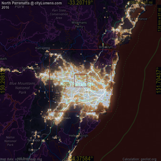
Analysis of North Parramatta night lights 2016
Square area 10x10 km:
 26.75%
90-99
31.47%80-89
12.76%70-79
23.78%60-69
5.24%50-59
0%40-49
0%30-39
0%20-29
0%10-19
0%0-9
0%Square area 50x50 km:
13.03%90-99
14.29%80-89
7.39%70-79
9.06%60-69
9.8%50-59
5.09%40-49
3.85%30-39
5.25%20-29
6.87%10-19
8.16%0-9
17.22%Clear (daylight) street map image can be seen on geolist.org.
Map coordinates:
33° 12' 25.9" South, 150° 17' 53.2" East
33° 47' 36.6" South, 151° 0' 4.5" East
34° 22' 33" South, 151° 42' 15.7" East
Some cities around North Parramatta sort by population:
• Baulkham Hills
3.9 km =2.4 mi,  348°
348°
• Parramatta
2.7 km =1.7 mi,  175°
175°
• Westmead
1.7 km =1.1 mi,  227°
227°
• Winston Hills
2.7 km =1.7 mi,  314°
314°
• Wentworthville
3.4 km =2.1 mi,  244°
244°
• Harris Park
3.3 km =2.1 mi,  169°
169°
• Oatlands
2.4 km =1.5 mi,  96°
96°
• Telopea
3.5 km =2.2 mi,  88°
88°
8299775 (p: 13,394)
Sources (retrieved 2019-11-25):
» Earth at Night: Flat Maps 2012, 2016