Pennant Hills night lights from space
Night Light of Pennant Hills (New South Wales) from space (Australia) Src. Average luminocity for 10x10km area is 69.6923% and for 50x50km: 48.3984%.
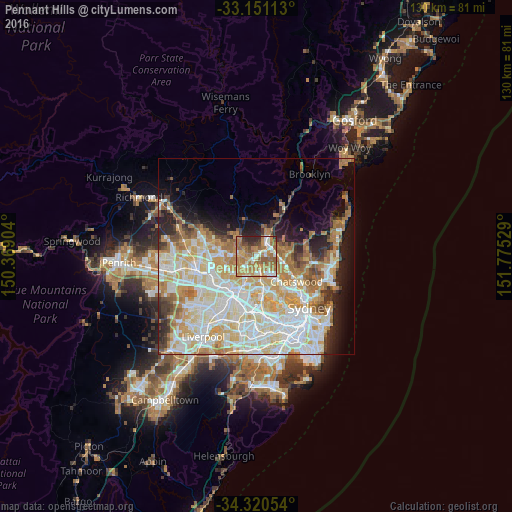
Analysis of Pennant Hills night lights 2016
Square area 10x10 km:
 7.51%
7.51%90-99
13.74%80-89
4.21%70-79
19.6%60-69
30.59%50-59
12.27%40-49
3.85%30-39
4.03%20-29
4.21%10-19
0%0-9
0%Square area 50x50 km:
11.79%90-99
13.1%80-89
7.01%70-79
8.05%60-69
8.14%50-59
3.39%40-49
2.46%30-39
3.35%20-29
4.7%10-19
7.05%0-9
30.96%Clear (daylight) street map image can be seen on geolist.org.
Map coordinates:
33° 9' 4.1" South, 150° 22' 8.5" East
33° 44' 16.2" South, 151° 4' 19.8" East
34° 19' 13.9" South, 151° 46' 31" East
Some cities around Pennant Hills sort by population:
• Epping
4 km =2.5 mi,  167°
167°
• Cherrybrook
3 km =1.9 mi,  306°
306°
• Wahroonga
4.6 km =2.9 mi,  61°
61°
• West Pennant Hills
2.4 km =1.5 mi,  248°
248°
• Beecroft
1.5 km =0.9 mi,  207°
207°
• Thornleigh
0.9 km =0.6 mi,  45°
45°
• Waitara
4.2 km =2.6 mi,  43°
43°
• Normanhurst
2.7 km =1.7 mi, 54°
2153483 (p: 7,199)
Sources (retrieved 2019-11-25):
» Earth at Night: Flat Maps 2012, 2016