Edensor Park night lights from space
Night Light of Edensor Park (New South Wales) from space (Australia) Src. Average luminocity for 10x10km area is 79.6836% and for 50x50km: 51.903%.
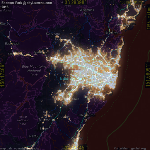
Analysis of Edensor Park night lights 2016
Square area 10x10 km:
 19.41%
90-99
24.48%80-89
11.89%70-79
15.91%60-69
10.14%50-59
7.17%40-49
4.55%30-39
5.77%20-29
0.7%10-19
0%0-9
0%Square area 50x50 km:
10.78%90-99
12.64%80-89
7.33%70-79
8.59%60-69
9.62%50-59
5.36%40-49
3.78%30-39
5.31%20-29
7.04%10-19
10%0-9
19.55%Clear (daylight) street map image can be seen on geolist.org.
Map coordinates:
33° 17' 38.3" South, 150° 10' 28.8" East
33° 52' 47" South, 150° 52' 40" East
34° 27' 41.2" South, 151° 34' 51.3" East
Some cities around Edensor Park sort by population:
• Bossley Park
2.1 km =1.3 mi,  16°
16°
• Green Valley
2.8 km =1.7 mi,  200°
200°
• Bonnyrigg
1.9 km =1.2 mi,  145°
145°
• Bonnyrigg Heights
1.5 km =0.9 mi,  209°
209°
• Cabramatta West
3.5 km =2.2 mi,  115°
115°
• Cecil Hills
2.7 km =1.7 mi,  246°
246°
• St Johns Park
2.2 km =1.4 mi,  99°
99°
• Greenfield Park
1.4 km =0.9 mi,  66°
66°
8347979 (p: 9,739)
Sources (retrieved 2019-11-25):
» Earth at Night: Flat Maps 2012, 2016