South Mackay night lights from space
Night Light of South Mackay (Queensland) from space (Australia) Src. Average luminocity for 10x10km area is 55.3591% and for 50x50km: 5.5946%.
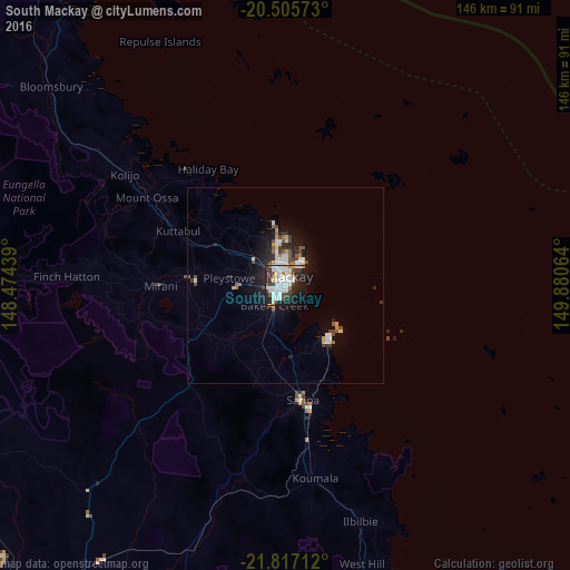
Analysis of South Mackay night lights 2016
Square area 10x10 km:
 16.67%
90-99
19.05%80-89
3.77%70-79
2.38%60-69
1.59%50-59
2.38%40-49
5.56%30-39
7.34%20-29
20.24%10-19
17.06%0-9
3.97%Square area 50x50 km:
1.04%90-99
1.37%80-89
0.29%70-79
0.47%60-69
0.4%50-59
0.54%40-49
0.85%30-39
0.65%20-29
1.69%10-19
3.81%0-9
88.89%Clear (daylight) street map image can be seen on geolist.org.
Map coordinates:
20° 30' 20.6" South, 148° 28' 27.8" East
21° 9' 46.4" South, 149° 10' 39" East
21° 49' 1.6" South, 149° 52' 50.3" East
Some cities around South Mackay sort by population:
• Mackay
1.6 km =1 mi,  310°
310°
• Andergrove
8.9 km =5.5 mi,  3°
3°
• West Mackay
1.9 km =1.2 mi,  299°
299°
• Cannonvale
110.4 km =68.6 mi,  333°
333°
• North Mackay
4.8 km =3 mi, 2°
• Sarina
28.8 km =17.9 mi,  171°
171°
• Red Hill
117.5 km =73 mi,  323°
323°
• Beaconsfield
8.1 km =5 mi,  351°
351°
10097514 (p: 6,494)
Sources (retrieved 2019-11-25):
» Earth at Night: Flat Maps 2012, 2016