West Hoxton night lights from space
Night Light of West Hoxton (New South Wales) from space (Australia) Src. Average luminocity for 10x10km area is 57.1521% and for 50x50km: 42.9736%.
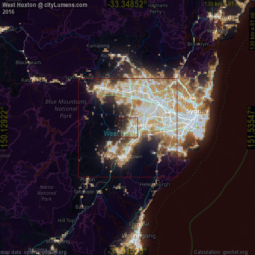
Analysis of West Hoxton night lights 2016
Square area 10x10 km:
 9.79%
9.79%90-99
11.89%80-89
5.07%70-79
12.24%60-69
11.01%50-59
5.94%40-49
6.82%30-39
12.41%20-29
13.99%10-19
10.14%0-9
0.7%Square area 50x50 km:
9.15%90-99
10.78%80-89
6.08%70-79
7.03%60-69
7.65%50-59
4.37%40-49
3.07%30-39
4.13%20-29
4.74%10-19
7.88%0-9
35.14%Clear (daylight) street map image can be seen on geolist.org.
Map coordinates:
33° 20' 54.7" South, 150° 7' 45.2" East
33° 56' 2" South, 150° 49' 56.4" East
34° 30' 54.9" South, 151° 32' 7.7" East
Some cities around West Hoxton sort by population:
• Casula
6.5 km =4 mi,  108°
108°
• Prestons
3.7 km =2.3 mi,  103°
103°
• Green Valley
4.7 km =2.9 mi,  42°
42°
• Hinchinbrook
3.3 km =2.1 mi,  59°
59°
• Lurnea
5.9 km =3.7 mi,  91°
91°
• Bonnyrigg Heights
5.9 km =3.7 mi, 36°
• Cecil Hills
5.3 km =3.3 mi,  19°
19°
• Middleton Grange
2.1 km =1.3 mi,  25°
25°
2143984 (p: 9,978)
Sources (retrieved 2019-11-25):
» Earth at Night: Flat Maps 2012, 2016