Norwood night lights from space
Night Light of Norwood (South Australia) from space (Australia) Src. Average luminocity for 10x10km area is 82.804% and for 50x50km: 27.265%.
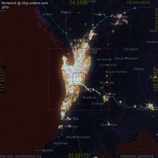
Analysis of Norwood night lights 2016
Square area 10x10 km:
 29.67%
90-99
21.43%80-89
8.24%70-79
16.85%60-69
9.52%50-59
7.51%40-49
3.11%30-39
0.37%20-29
2.93%10-19
0.37%0-9
0%Square area 50x50 km:
5.79%90-99
6.03%80-89
2.72%70-79
4.93%60-69
4.32%50-59
3.77%40-49
2.72%30-39
2.22%20-29
4.41%10-19
8.01%0-9
55.07%Clear (daylight) street map image can be seen on geolist.org.
Map coordinates:
34° 20' 55.7" South, 137° 55' 31.3" East
34° 55' 38.3" South, 138° 37' 42.6" East
35° 30' 6.3" South, 139° 19' 53.8" East
Some cities around Norwood sort by population:
• Adelaide
2.7 km =1.7 mi,  266°
266°
• Adelaide city centre
2.3 km =1.4 mi, 266°
• Prospect
5.9 km =3.7 mi,  327°
327°
• Magill
4.7 km =2.9 mi,  64°
64°
• Campbelltown
6 km =3.7 mi,  35°
35°
• North Adelaide
4 km =2.5 mi,  303°
303°
• Rostrevor
6.9 km =4.3 mi, 57°
• Klemzig
5.4 km =3.4 mi,  6°
6°
9973143 (p: 5,803)
Sources (retrieved 2019-11-25):
» Earth at Night: Flat Maps 2012, 2016