North Adelaide night lights from space
Night Light of North Adelaide (South Australia) from space (Australia) Src. Average luminocity for 10x10km area is 96.7216% and for 50x50km: 27.2055%.
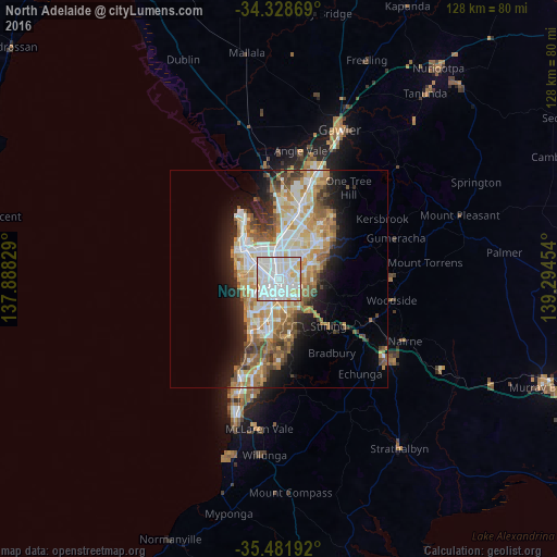
Analysis of North Adelaide night lights 2016
Square area 10x10 km:
 48.9%
48.9%90-99
38.46%80-89
9.16%70-79
3.48%60-69
0%50-59
0%40-49
0%30-39
0%20-29
0%10-19
0%0-9
0%Square area 50x50 km:
5.81%90-99
6.12%80-89
2.77%70-79
4.98%60-69
4.24%50-59
3.61%40-49
2.68%30-39
2.17%20-29
4.42%10-19
7.96%0-9
55.24%Clear (daylight) street map image can be seen on geolist.org.
Map coordinates:
34° 19' 43.3" South, 137° 53' 17.8" East
34° 54' 26.4" South, 138° 35' 29.1" East
35° 28' 54.9" South, 139° 17' 40.3" East
Some cities around North Adelaide sort by population:
• Adelaide
2.5 km =1.6 mi,  164°
164°
• Adelaide city centre
2.6 km =1.6 mi, 155°
• Prospect
2.8 km =1.7 mi,  3°
3°
• Findon
5.4 km =3.4 mi,  278°
278°
• Klemzig
5.1 km =3.2 mi,  52°
52°
• Norwood
4 km =2.5 mi,  123°
123°
• Lockleys
6.1 km =3.8 mi,  250°
250°
• Kilburn
5.3 km =3.3 mi,  354°
354°
8469169 (p: 7,794)
Sources (retrieved 2019-11-25):
» Earth at Night: Flat Maps 2012, 2016