Klemzig night lights from space
Night Light of Klemzig (South Australia) from space (Australia) Src. Average luminocity for 10x10km area is 89.2564% and for 50x50km: 27.7218%.
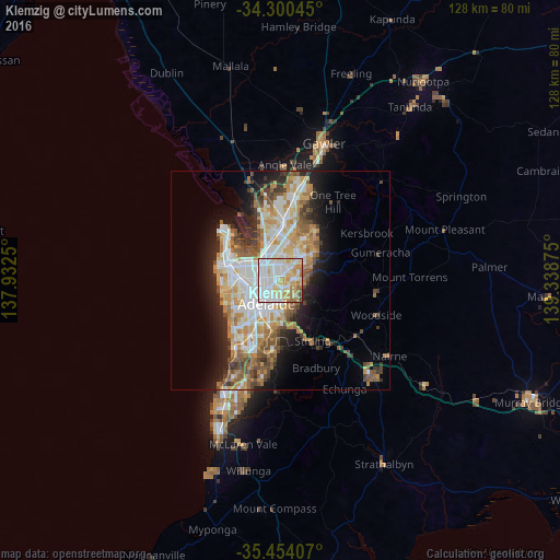
Analysis of Klemzig night lights 2016
Square area 10x10 km:
 29.85%
90-99
30.4%80-89
16.3%70-79
13.55%60-69
6.78%50-59
2.01%40-49
0.73%30-39
0.37%20-29
0%10-19
0%0-9
0%Square area 50x50 km:
5.84%90-99
6.12%80-89
2.84%70-79
5.01%60-69
4.21%50-59
3.73%40-49
2.81%30-39
2.56%20-29
4.72%10-19
8.11%0-9
54.03%Clear (daylight) street map image can be seen on geolist.org.
Map coordinates:
34° 18' 1.6" South, 137° 55' 57" East
34° 52' 45.4" South, 138° 38' 8.2" East
35° 27' 14.7" South, 139° 20' 19.5" East
Some cities around Klemzig sort by population:
• Prospect
3.9 km =2.4 mi,  264°
264°
• Magill
4.9 km =3 mi,  132°
132°
• Campbelltown
2.9 km =1.8 mi,  99°
99°
• Paradise
3.1 km =1.9 mi,  78°
78°
• Northgate
2.5 km =1.6 mi,  345°
345°
• Valley View
4.9 km =3 mi,  27°
27°
• Enfield
4.2 km =2.6 mi,  314°
314°
• Windsor Gardens
1.9 km =1.2 mi, 33°
6621338 (p: 6,018)
Sources (retrieved 2019-11-25):
» Earth at Night: Flat Maps 2012, 2016