Findon night lights from space
Night Light of Findon (South Australia) from space (Australia) Src. Average luminocity for 10x10km area is 87.3791% and for 50x50km: 26.9171%.
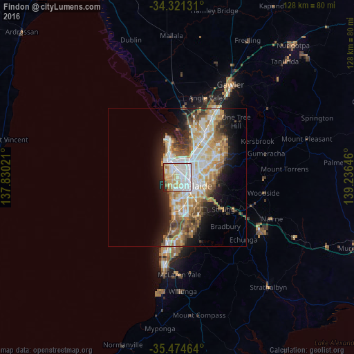
Analysis of Findon night lights 2016
Square area 10x10 km:
 33.15%
90-99
28.94%80-89
12.09%70-79
14.65%60-69
3.66%50-59
1.65%40-49
1.47%30-39
0.92%20-29
3.48%10-19
0%0-9
0%Square area 50x50 km:
5.81%90-99
6.13%80-89
2.77%70-79
4.93%60-69
4.12%50-59
3.49%40-49
2.55%30-39
2.16%20-29
4.49%10-19
7.94%0-9
55.6%Clear (daylight) street map image can be seen on geolist.org.
Map coordinates:
34° 19' 16.7" South, 137° 49' 48.8" East
34° 54' 0" South, 138° 31' 60" East
35° 28' 28.7" South, 139° 14' 11.3" East
Some cities around Findon sort by population:
• Prospect
5.8 km =3.6 mi,  70°
70°
• Seaton
1.5 km =0.9 mi,  270°
270°
• North Adelaide
5.4 km =3.4 mi,  98°
98°
• Fulham Gardens
2.5 km =1.6 mi,  228°
228°
• Henley Beach
4.2 km =2.6 mi,  237°
237°
• Grange
3.9 km =2.4 mi, 266°
• West Lakes
4.6 km =2.9 mi,  310°
310°
• Lockleys
2.9 km =1.8 mi,  189°
189°
2071601 (p: 6,178)
Sources (retrieved 2019-11-25):
» Earth at Night: Flat Maps 2012, 2016