Niddrie night lights from space
Night Light of Niddrie (Victoria) from space (Australia) Src. Average luminocity for 10x10km area is 90.3571% and for 50x50km: 50.7529%.
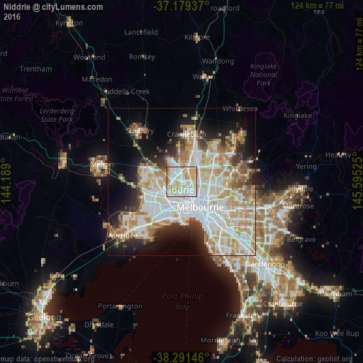
Analysis of Niddrie night lights 2016
Square area 10x10 km:
 28.4%
28.4%90-99
28.74%80-89
21.6%70-79
18.54%60-69
2.21%50-59
0.34%40-49
0.17%30-39
0%20-29
0%10-19
0%0-9
0%Square area 50x50 km:
14.11%90-99
12.66%80-89
6.58%70-79
8.51%60-69
5.99%50-59
3.97%40-49
3.45%30-39
3.61%20-29
6.07%10-19
9.96%0-9
25.09%Clear (daylight) street map image can be seen on geolist.org.
Map coordinates:
37° 10' 45.7" South, 144° 11' 20.4" East
37° 44' 15" South, 144° 53' 31.6" East
38° 17' 29.3" South, 145° 35' 42.9" East
Some cities around Niddrie sort by population:
• Essendon
2.1 km =1.3 mi,  129°
129°
• Pascoe Vale
3.7 km =2.3 mi,  82°
82°
• Keilor East
2.4 km =1.5 mi,  282°
282°
• Moonee Ponds
3.9 km =2.4 mi,  146°
146°
• Avondale Heights
3.7 km =2.3 mi,  224°
224°
• Strathmore
2.5 km =1.6 mi,  85°
85°
• Airport West
1.7 km =1.1 mi,  326°
326°
• Oak Park
3.2 km =2 mi,  48°
48°
6290237 (p: 5,443)
Sources (retrieved 2019-11-25):
» Earth at Night: Flat Maps 2012, 2016