Keilor East night lights from space
Night Light of Keilor East (Victoria) from space (Australia) Src. Average luminocity for 10x10km area is 87.7177% and for 50x50km: 49.1355%.
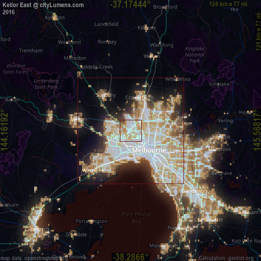
Analysis of Keilor East night lights 2016
Square area 10x10 km:
 25%
25%90-99
29.59%80-89
17.69%70-79
18.2%60-69
4.93%50-59
2.21%40-49
1.7%30-39
0.68%20-29
0%10-19
0%0-9
0%Square area 50x50 km:
13.74%90-99
12.18%80-89
6.3%70-79
8.13%60-69
5.66%50-59
4.01%40-49
3.33%30-39
3.54%20-29
5.86%10-19
10.2%0-9
27.05%Clear (daylight) street map image can be seen on geolist.org.
Map coordinates:
37° 10' 28" South, 144° 9' 42.9" East
37° 43' 57.4" South, 144° 51' 54.1" East
38° 17' 11.8" South, 145° 34' 5.4" East
Some cities around Keilor East sort by population:
• Essendon
4.5 km =2.8 mi,  115°
115°
• Maribyrnong
4.7 km =2.9 mi,  159°
159°
• Avondale Heights
3.2 km =2 mi,  183°
183°
• Strathmore
4.9 km =3 mi,  93°
93°
• Airport West
1.7 km =1.1 mi,  58°
58°
• Tullamarine
3.8 km =2.4 mi,  21°
21°
• Oak Park
5 km =3.1 mi,  71°
71°
• Niddrie
2.4 km =1.5 mi,  102°
102°
9972422 (p: 14,311)
Sources (retrieved 2019-11-25):
» Earth at Night: Flat Maps 2012, 2016