Pascoe Vale night lights from space
Night Light of Pascoe Vale (Victoria) from space (Australia) Src. Average luminocity for 10x10km area is 91.3231% and for 50x50km: 52.063%.
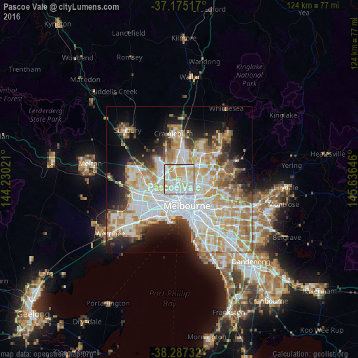
Analysis of Pascoe Vale night lights 2016
Square area 10x10 km:
 29.93%
90-99
29.42%80-89
24.83%70-79
15.65%60-69
0.17%50-59
0%40-49
0%30-39
0%20-29
0%10-19
0%0-9
0%Square area 50x50 km:
14.38%90-99
12.85%80-89
6.68%70-79
8.75%60-69
6.87%50-59
4.23%40-49
3.55%30-39
3.61%20-29
6.04%10-19
9.37%0-9
23.65%Clear (daylight) street map image can be seen on geolist.org.
Map coordinates:
37° 10' 30.6" South, 144° 13' 48.8" East
37° 43' 60" South, 144° 55' 60" East
38° 17' 14.4" South, 145° 38' 11.3" East
Some cities around Pascoe Vale sort by population:
• Coburg
3.5 km =2.2 mi,  122°
122°
• Essendon
2.7 km =1.7 mi,  227°
227°
• Fawkner
3.5 km =2.2 mi,  57°
57°
• Brunswick West
3.6 km =2.2 mi,  165°
165°
• Strathmore
1.1 km =0.7 mi,  257°
257°
• Coburg North
2.5 km =1.6 mi,  78°
78°
• Oak Park
2.1 km =1.3 mi,  323°
323°
• Hadfield
3 km =1.9 mi,  14°
14°
2153720 (p: 16,850)
Sources (retrieved 2019-11-25):
» Earth at Night: Flat Maps 2012, 2016