Nicholls night lights from space
Night Light of Nicholls (ACT) from space (Australia) Src. Average luminocity for 10x10km area is 62.8846% and for 50x50km: 14.2471%.
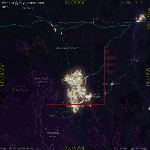
Analysis of Nicholls night lights 2016
Square area 10x10 km:
 8.04%
8.04%90-99
12.06%80-89
11.54%70-79
14.69%60-69
18.01%50-59
7.34%40-49
2.27%30-39
5.42%20-29
9.09%10-19
10.66%0-9
0.87%Square area 50x50 km:
2.32%90-99
2.83%80-89
1.32%70-79
2.14%60-69
3.49%50-59
1.73%40-49
1.27%30-39
2.45%20-29
2.9%10-19
5.43%0-9
74.12%Clear (daylight) street map image can be seen on geolist.org.
Map coordinates:
34° 36' 38.4" South, 148° 23' 36.1" East
35° 11' 14.4" South, 149° 5' 47.3" East
35° 45' 35.8" South, 149° 47' 58.6" East
Some cities around Nicholls sort by population:
• Ngunnawal
2.1 km =1.3 mi,  40°
40°
• Kaleen
3.5 km =2.2 mi,  167°
167°
• Franklin
4.5 km =2.8 mi,  107°
107°
• Gungahlin
3.6 km =2.2 mi,  88°
88°
• Casey
2.3 km =1.4 mi,  355°
355°
• Amaroo
3.5 km =2.2 mi,  55°
55°
• Palmerston
2.2 km =1.4 mi, 110°
• Evatt
3.7 km =2.3 mi,  222°
222°
8349185 (p: 6,910)
Sources (retrieved 2019-11-25):
» Earth at Night: Flat Maps 2012, 2016