Benowa night lights from space
Night Light of Benowa (Queensland) from space (Australia) Src. Average luminocity for 10x10km area is 84.2273% and for 50x50km: 16.2949%.
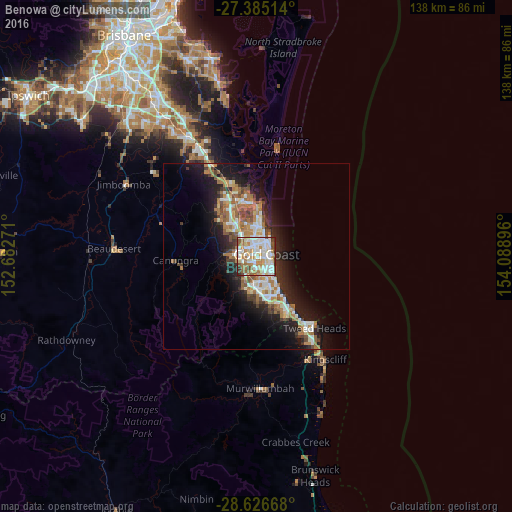
Analysis of Benowa night lights 2016
Square area 10x10 km:
 27.65%
90-99
27.08%80-89
9.09%70-79
10.04%60-69
13.83%50-59
7.39%40-49
2.84%30-39
1.7%20-29
0.38%10-19
0%0-9
0%Square area 50x50 km:
2.81%90-99
2.99%80-89
1.51%70-79
1.22%60-69
4.61%50-59
1.72%40-49
1.9%30-39
1.91%20-29
4.01%10-19
9.97%0-9
67.34%Clear (daylight) street map image can be seen on geolist.org.
Map coordinates:
27° 23' 6.5" South, 152° 40' 57.8" East
28° 0' 27.7" South, 153° 23' 9" East
28° 37' 36" South, 154° 5' 20.3" East
Some cities around Benowa sort by population:
• Gold Coast
4.5 km =2.8 mi,  79°
79°
• Southport
4.7 km =2.9 mi,  14°
14°
• Surfers Paradise
4.4 km =2.7 mi, 82°
• Carrara
2.5 km =1.6 mi,  231°
231°
• Ashmore
2.3 km =1.4 mi,  336°
336°
• Broadbeach Waters
4.9 km =3 mi,  128°
128°
• Merrimac
5 km =3.1 mi,  194°
194°
• Molendinar
4.5 km =2.8 mi,  326°
326°
2176127 (p: 9,015)
Sources (retrieved 2019-11-25):
» Earth at Night: Flat Maps 2012, 2016