Narellan Vale night lights from space
Night Light of Narellan Vale (New South Wales) from space (Australia) Src. Average luminocity for 10x10km area is 56.535% and for 50x50km: 19.8152%.
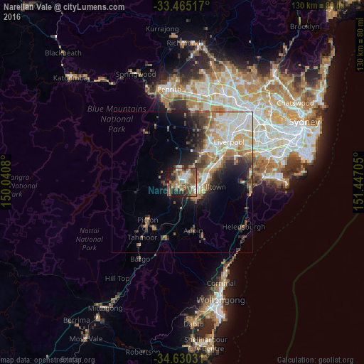
Analysis of Narellan Vale night lights 2016
Square area 10x10 km:
 8.74%
8.74%90-99
8.22%80-89
3.32%70-79
7.17%60-69
18.01%50-59
17.48%40-49
9.44%30-39
6.64%20-29
10.84%10-19
10.14%0-9
0%Square area 50x50 km:
3.55%90-99
4.03%80-89
2.26%70-79
2.72%60-69
3.82%50-59
2.73%40-49
2.16%30-39
3.23%20-29
3.63%10-19
5.9%0-9
65.96%Clear (daylight) street map image can be seen on geolist.org.
Map coordinates:
33° 27' 54.6" South, 150° 2' 26.9" East
34° 2' 59.1" South, 150° 44' 38.1" East
34° 37' 49.1" South, 151° 26' 49.4" East
Some cities around Narellan Vale sort by population:
• Campbelltown
7 km =4.3 mi,  105°
105°
• Mount Annan
1.5 km =0.9 mi,  103°
103°
• Harrington Park
3 km =1.9 mi,  343°
343°
• Rosemeadow
7.5 km =4.7 mi,  143°
143°
• Ambarvale
6.6 km =4.1 mi,  132°
132°
• Raby
7.6 km =4.7 mi,  62°
62°
• Eagle Vale
6.6 km =4.1 mi,  78°
78°
• Currans Hill
2.8 km =1.7 mi,  74°
74°
9972832 (p: 7,160)
Sources (retrieved 2019-11-25):
» Earth at Night: Flat Maps 2012, 2016