Rosemeadow night lights from space
Night Light of Rosemeadow (New South Wales) from space (Australia) Src. Average luminocity for 10x10km area is 36.9011% and for 50x50km: 18.9535%.
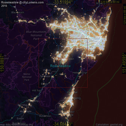
Analysis of Rosemeadow night lights 2016
Square area 10x10 km:
 4.76%
4.76%90-99
4.21%80-89
2.56%70-79
5.31%60-69
11.54%50-59
6.41%40-49
6.59%30-39
6.23%20-29
6.78%10-19
21.79%0-9
23.81%Square area 50x50 km:
2.95%90-99
3.6%80-89
2.06%70-79
2.67%60-69
4.18%50-59
3.07%40-49
2.24%30-39
3.02%20-29
3.43%10-19
5.85%0-9
66.92%Clear (daylight) street map image can be seen on geolist.org.
Map coordinates:
33° 31' 11.8" South, 150° 5' 22.9" East
34° 6' 14.9" South, 150° 47' 34.2" East
34° 41' 3.6" South, 151° 29' 45.4" East
Some cities around Rosemeadow sort by population:
• Campbelltown
4.7 km =2.9 mi,  27°
27°
• Mount Annan
6.5 km =4 mi,  331°
331°
• Leumeah
7.1 km =4.4 mi, 31°
• Bradbury
2.9 km =1.8 mi,  44°
44°
• Ambarvale
1.7 km =1.1 mi,  11°
11°
• St Helens Park
1.9 km =1.2 mi,  91°
91°
• Ruse
5.9 km =3.7 mi,  49°
49°
• Currans Hill
7 km =4.3 mi,  344°
344°
8348741 (p: 7,756)
Sources (retrieved 2019-11-25):
» Earth at Night: Flat Maps 2012, 2016