Currans Hill night lights from space
Night Light of Currans Hill (New South Wales) from space (Australia) Src. Average luminocity for 10x10km area is 68.451% and for 50x50km: 22.9672%.
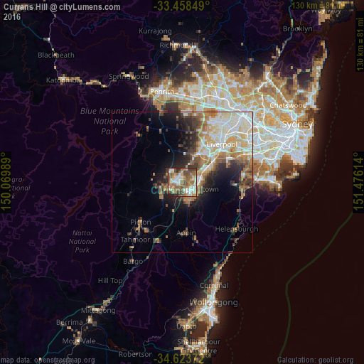
Analysis of Currans Hill night lights 2016
Square area 10x10 km:
 13.46%
90-99
13.11%80-89
7.69%70-79
8.74%60-69
19.58%50-59
17.31%40-49
9.97%30-39
4.9%20-29
4.9%10-19
0.35%0-9
0%Square area 50x50 km:
4.36%90-99
4.98%80-89
2.69%70-79
2.98%60-69
4.39%50-59
3.08%40-49
2.44%30-39
3.42%20-29
3.78%10-19
6.37%0-9
61.53%Clear (daylight) street map image can be seen on geolist.org.
Map coordinates:
33° 27' 30.6" South, 150° 4' 11.6" East
34° 2' 35.2" South, 150° 46' 22.8" East
34° 37' 25.4" South, 151° 28' 34.1" East
Some cities around Currans Hill sort by population:
• Campbelltown
4.8 km =3 mi,  123°
123°
• Mount Annan
1.6 km =1 mi,  228°
228°
• Harrington Park
4.1 km =2.5 mi,  301°
301°
• Leumeah
5.6 km =3.5 mi,  97°
97°
• Ambarvale
5.6 km =3.5 mi,  157°
157°
• Narellan Vale
2.8 km =1.7 mi,  254°
254°
• Raby
4.9 km =3 mi,  56°
56°
• Eagle Vale
3.8 km =2.4 mi,  80°
80°
8348822 (p: 5,251)
Sources (retrieved 2019-11-25):
» Earth at Night: Flat Maps 2012, 2016