Ambarvale night lights from space
Night Light of Ambarvale (New South Wales) from space (Australia) Src. Average luminocity for 10x10km area is 47.7622% and for 50x50km: 20.2715%.
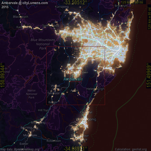
Analysis of Ambarvale night lights 2016
Square area 10x10 km:
 7.34%
7.34%90-99
6.29%80-89
3.5%70-79
6.99%60-69
15.91%50-59
10.66%40-49
6.82%30-39
5.94%20-29
6.47%10-19
20.8%0-9
9.27%Square area 50x50 km:
3.24%90-99
4.11%80-89
2.42%70-79
2.81%60-69
4.25%50-59
3.09%40-49
2.29%30-39
3.14%20-29
3.55%10-19
5.77%0-9
65.33%Clear (daylight) street map image can be seen on geolist.org.
Map coordinates:
33° 30' 18.4" South, 150° 5' 36.4" East
34° 5' 21.9" South, 150° 47' 47.6" East
34° 40' 11" South, 151° 29' 58.9" East
Some cities around Ambarvale sort by population:
• Campbelltown
3.1 km =1.9 mi,  36°
36°
• Mount Annan
5.3 km =3.3 mi,  320°
320°
• Leumeah
5.5 km =3.4 mi, 37°
• Bradbury
1.8 km =1.1 mi,  75°
75°
• Rosemeadow
1.7 km =1.1 mi,  191°
191°
• St Helens Park
2.3 km =1.4 mi,  137°
137°
• Ruse
4.7 km =2.9 mi,  62°
62°
• Currans Hill
5.6 km =3.5 mi,  337°
337°
8348417 (p: 7,333)
Sources (retrieved 2019-11-25):
» Earth at Night: Flat Maps 2012, 2016