Mount Evelyn night lights from space
Night Light of Mount Evelyn (Victoria) from space (Australia) Src. Average luminocity for 10x10km area is 21.1599% and for 50x50km: 19.6853%.
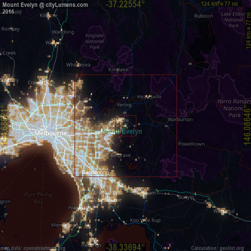
Analysis of Mount Evelyn night lights 2016
Square area 10x10 km:
 1.19%
1.19%90-99
1.19%80-89
1.19%70-79
3.74%60-69
4.08%50-59
3.91%40-49
5.1%30-39
9.69%20-29
7.14%10-19
11.56%0-9
51.19%Square area 50x50 km:
2.95%90-99
3.58%80-89
1.91%70-79
4.3%60-69
4.74%50-59
3.55%40-49
2.51%30-39
1.73%20-29
2.96%10-19
4.68%0-9
67.09%Clear (daylight) street map image can be seen on geolist.org.
Map coordinates:
37° 13' 31.9" South, 144° 40' 48.8" East
37° 46' 60" South, 145° 22' 60" East
38° 20' 13" South, 146° 5' 11.3" East
Some cities around Mount Evelyn sort by population:
• Croydon
9 km =5.6 mi,  258°
258°
• Mooroolbark
5.8 km =3.6 mi,  270°
270°
• Lilydale
4.7 km =2.9 mi,  321°
321°
• Kilsyth
6.1 km =3.8 mi,  252°
252°
• Chirnside Park
7.8 km =4.8 mi,  309°
309°
• Bayswater North
8.9 km =5.5 mi,  237°
237°
• Croydon North
8.3 km =5.2 mi,  282°
282°
• Montrose
4.7 km =2.9 mi,  218°
218°
2156652 (p: 9,467)
Sources (retrieved 2019-11-25):
» Earth at Night: Flat Maps 2012, 2016