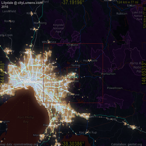
Lilydale night lights from space
Night Light of Lilydale (Victoria) from space (Australia) Src. Average luminocity for 10x10km area is 26.2041% and for 50x50km: 21.3589%.
Analysis of Lilydale night lights 2016
Square area 10x10 km:
 1.53%
1.53%90-99
1.87%80-89
1.53%70-79
4.25%60-69
6.63%50-59
4.42%40-49
7.65%30-39
9.01%20-29
4.25%10-19
17.52%0-9
41.33%Square area 50x50 km:
3.06%90-99
3.92%80-89
2.36%70-79
4.98%60-69
5.01%50-59
3.66%40-49
2.74%30-39
1.86%20-29
2.85%10-19
4.58%0-9
64.97%Clear (daylight) street map image can be seen on geolist.org.
Map coordinates:
37° 11' 31.1" South, 144° 38' 48.8" East
37° 45' 0" South, 145° 21' 0" East
38° 18' 13.9" South, 146° 3' 11.3" East
Some cities around Lilydale sort by population:
• Croydon
8.1 km =5 mi,  226°
226°
• Mooroolbark
4.6 km =2.9 mi,  218°
218°
• Kilsyth
6.3 km =3.9 mi,  207°
207°
• Chirnside Park
3.4 km =2.1 mi,  291°
291°
• Mount Evelyn
4.7 km =2.9 mi,  141°
141°
• Bayswater North
9.6 km =6 mi, 208°
• Croydon North
5.6 km =3.5 mi,  249°
249°
• Montrose
7.4 km =4.6 mi,  180°
180°
2160188 (p: 16,209)
Sources (retrieved 2019-11-25):
» Earth at Night: Flat Maps 2012, 2016