Redland Bay night lights from space
Night Light of Redland Bay (Queensland) from space (Australia) Src. Average luminocity for 10x10km area is 27.3591% and for 50x50km: 24.2794%.
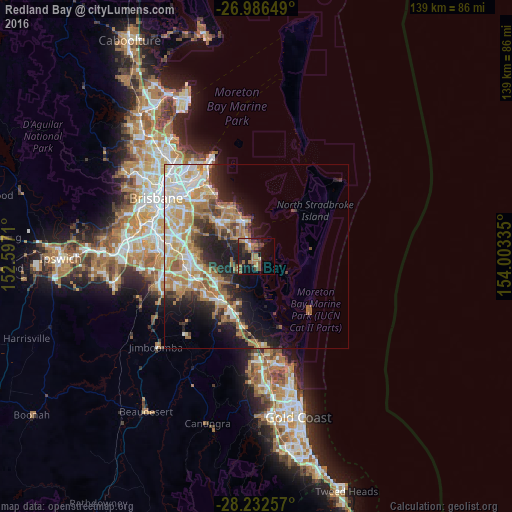
Analysis of Redland Bay night lights 2016
Square area 10x10 km:
 0.4%
0.4%90-99
1.59%80-89
1.59%70-79
2.58%60-69
15.67%50-59
2.18%40-49
3.97%30-39
6.75%20-29
7.94%10-19
23.81%0-9
33.53%Square area 50x50 km:
3.97%90-99
4.67%80-89
3%70-79
3.52%60-69
7.02%50-59
1.69%40-49
2.37%30-39
2.93%20-29
5.06%10-19
9.27%0-9
56.5%Clear (daylight) street map image can be seen on geolist.org.
Map coordinates:
26° 59' 11.4" South, 152° 35' 49.6" East
27° 36' 40.7" South, 153° 18' 0.8" East
28° 13' 57.3" South, 154° 0' 12.1" East
Some cities around Redland Bay sort by population:
• Alexandra Hills
11.3 km =7 mi,  321°
321°
• Victoria Point
3.3 km =2.1 mi,  19°
19°
• Cleveland
10 km =6.2 mi,  339°
339°
• Thornlands
6.9 km =4.3 mi,  329°
329°
• Eagleby
11.5 km =7.1 mi,  225°
225°
• Cornubia
10.3 km =6.4 mi, 233°
• Mount Cotton
7 km =4.3 mi,  249°
249°
• Ormiston
11.6 km =7.2 mi, 334°
2151892 (p: 14,626)
Sources (retrieved 2019-11-25):
» Earth at Night: Flat Maps 2012, 2016