Booragoon night lights from space
Night Light of Booragoon (Western Australia) from space (Australia) Src. Average luminocity for 10x10km area is 82.0594% and for 50x50km: 41.4222%.
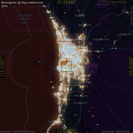
Analysis of Booragoon night lights 2016
Square area 10x10 km:
 16.61%
90-99
23.78%80-89
17.13%70-79
22.73%60-69
9.44%50-59
4.72%40-49
5.59%30-39
0%20-29
0%10-19
0%0-9
0%Square area 50x50 km:
9.3%90-99
9.98%80-89
4.72%70-79
6.04%60-69
8.05%50-59
4.81%40-49
3.5%30-39
3.52%20-29
6.68%10-19
8.46%0-9
34.93%Clear (daylight) street map image can be seen on geolist.org.
Map coordinates:
31° 26' 29.4" South, 115° 7' 50.1" East
32° 2' 22" South, 115° 50' 1.3" East
32° 38' 0.7" South, 116° 32' 12.6" East
Some cities around Booragoon sort by population:
• Kardinya
3.4 km =2.1 mi,  211°
211°
• Bull Creek
3.3 km =2.1 mi,  124°
124°
• Palmyra
4.5 km =2.8 mi,  262°
262°
• Applecross
2.5 km =1.6 mi,  359°
359°
• Mount Pleasant
1.5 km =0.9 mi,  91°
91°
• Attadale
3.4 km =2.1 mi,  298°
298°
• Winthrop
1.5 km =0.9 mi,  194°
194°
• Melville
3.1 km =1.9 mi,  268°
268°
8348406 (p: 5,404)
Sources (retrieved 2019-11-25):
» Earth at Night: Flat Maps 2012, 2016