Stafford night lights from space
Night Light of Stafford (Queensland) from space (Australia) Src. Average luminocity for 10x10km area is 87.9678% and for 50x50km: 41.1509%.
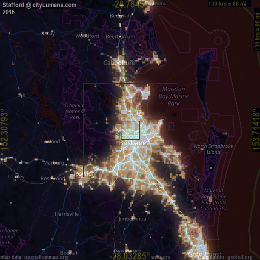
Analysis of Stafford night lights 2016
Square area 10x10 km:
 23.48%
90-99
28.22%80-89
25.76%70-79
11.36%60-69
7.95%50-59
2.46%40-49
0.76%30-39
0%20-29
0%10-19
0%0-9
0%Square area 50x50 km:
8.31%90-99
9.02%80-89
5.43%70-79
5.8%60-69
10.38%50-59
3.59%40-49
4.15%30-39
3.94%20-29
6.44%10-19
8.83%0-9
34.1%Clear (daylight) street map image can be seen on geolist.org.
Map coordinates:
26° 47' 4.2" South, 152° 18' 28.5" East
27° 24' 37.6" South, 153° 0' 39.8" East
28° 1' 58.3" South, 153° 42' 51" East
Some cities around Stafford sort by population:
• Chermside
3.5 km =2.2 mi,  34°
34°
• Wavell Heights
4 km =2.5 mi,  62°
62°
• Kedron
2 km =1.2 mi,  65°
65°
• Everton Park
2.3 km =1.4 mi,  278°
278°
• McDowall
3.6 km =2.2 mi,  328°
328°
• Windsor
3.4 km =2.1 mi,  148°
148°
• Chermside West
3 km =1.9 mi,  9°
9°
• Alderley
1.9 km =1.2 mi,  210°
210°
9957327 (p: 6,423)
Sources (retrieved 2019-11-25):
» Earth at Night: Flat Maps 2012, 2016