Huntingdale night lights from space
Night Light of Huntingdale (Western Australia) from space (Australia) Src. Average luminocity for 10x10km area is 79.7797% and for 50x50km: 39.4893%.
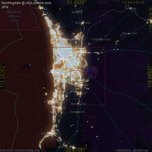
Analysis of Huntingdale night lights 2016
Square area 10x10 km:
 15.73%
90-99
20.98%80-89
12.24%70-79
21.15%60-69
17.48%50-59
8.22%40-49
4.02%30-39
0.17%20-29
0%10-19
0%0-9
0%Square area 50x50 km:
8.93%90-99
9.42%80-89
4.27%70-79
5.42%60-69
8.1%50-59
5.14%40-49
3.46%30-39
3.24%20-29
5.72%10-19
8.02%0-9
38.27%Clear (daylight) street map image can be seen on geolist.org.
Map coordinates:
31° 29' 7.8" South, 115° 15' 46.9" East
32° 4' 59.4" South, 115° 57' 58.1" East
32° 40' 37.1" South, 116° 40' 9.4" East
Some cities around Huntingdale sort by population:
• Canning Vale
5.3 km =3.3 mi,  301°
301°
• Thornlie
2.8 km =1.7 mi,  337°
337°
• Gosnells
3.7 km =2.3 mi,  86°
86°
• Maddington
4 km =2.5 mi,  23°
23°
• Southern River
2.7 km =1.7 mi,  194°
194°
• Harrisdale
4.2 km =2.6 mi,  223°
223°
• Kenwick
5.5 km =3.4 mi,  0°
0°
• Langford
5.2 km =3.2 mi,  333°
333°
8349269 (p: 8,525)
Sources (retrieved 2019-11-25):
» Earth at Night: Flat Maps 2012, 2016