Dallas night lights from space
Night Light of Dallas (Victoria) from space (Australia) Src. Average luminocity for 10x10km area is 82.2177% and for 50x50km: 45.5294%.
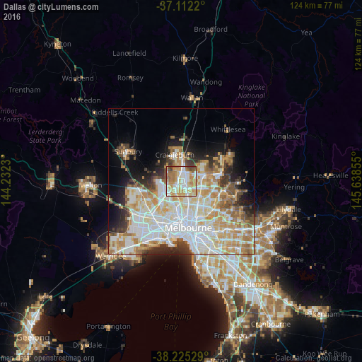
Analysis of Dallas night lights 2016
Square area 10x10 km:
 22.62%
90-99
19.22%80-89
14.12%70-79
20.92%60-69
12.93%50-59
6.29%40-49
2.72%30-39
1.19%20-29
0%10-19
0%0-9
0%Square area 50x50 km:
12.89%90-99
11.25%80-89
5.81%70-79
7.26%60-69
6.01%50-59
3.83%40-49
3.38%30-39
3.23%20-29
4.98%10-19
7.09%0-9
34.27%Clear (daylight) street map image can be seen on geolist.org.
Map coordinates:
37° 6' 43.9" South, 144° 13' 56.3" East
37° 40' 15" South, 144° 56' 7.5" East
38° 13' 31" South, 145° 38' 18.8" East
Some cities around Dallas sort by population:
• Glenroy
3.2 km =2 mi,  183°
183°
• Roxburgh Park
5.1 km =3.2 mi,  350°
350°
• Meadow Heights
2.6 km =1.6 mi,  325°
325°
• Broadmeadows
1.8 km =1.1 mi,  234°
234°
• Gladstone Park
4.7 km =2.9 mi,  246°
246°
• Westmeadows
4.3 km =2.7 mi,  262°
262°
• Hadfield
4.1 km =2.5 mi,  172°
172°
• Campbellfield
2.3 km =1.4 mi,  69°
69°
8348303 (p: 6,819)
Sources (retrieved 2019-11-25):
» Earth at Night: Flat Maps 2012, 2016