Kippa-Ring night lights from space
Night Light of Kippa-Ring (Queensland) from space (Australia) Src. Average luminocity for 10x10km area is 49.6686% and for 50x50km: 22.7585%.
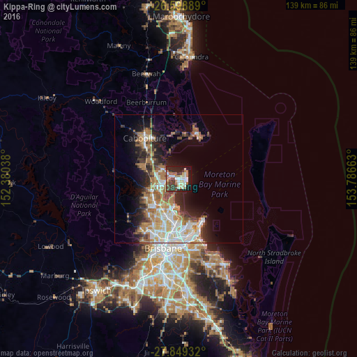
Analysis of Kippa-Ring night lights 2016
Square area 10x10 km:
 7.2%
7.2%90-99
9.66%80-89
8.33%70-79
1.14%60-69
14.2%50-59
4.55%40-49
7.77%30-39
10.61%20-29
13.83%10-19
21.21%0-9
1.52%Square area 50x50 km:
4.08%90-99
4.39%80-89
2.73%70-79
1.97%60-69
6.41%50-59
2.06%40-49
2.52%30-39
3.12%20-29
4.34%10-19
8.96%0-9
59.42%Clear (daylight) street map image can be seen on geolist.org.
Map coordinates:
26° 35' 56" South, 152° 22' 49.4" East
27° 13' 33.1" South, 153° 5' 0.6" East
27° 50' 57.6" South, 153° 47' 11.9" East
Some cities around Kippa-Ring sort by population:
• North Lakes
6.2 km =3.9 mi,  271°
271°
• Deception Bay
6.7 km =4.2 mi,  302°
302°
• Scarborough
3.8 km =2.4 mi,  43°
43°
• Mango Hill
6.2 km =3.9 mi,  251°
251°
• Clontarf
3.1 km =1.9 mi,  189°
189°
• Margate
2.8 km =1.7 mi,  149°
149°
• Rothwell
3.9 km =2.4 mi,  289°
289°
• Griffin
6.7 km =4.2 mi,  220°
220°
7932689 (p: 9,680)
Sources (retrieved 2019-11-25):
» Earth at Night: Flat Maps 2012, 2016