Griffin night lights from space
Night Light of Griffin (Queensland) from space (Australia) Src. Average luminocity for 10x10km area is 60.9924% and for 50x50km: 27.3537%.
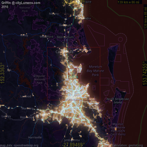
Analysis of Griffin night lights 2016
Square area 10x10 km:
 9.28%
9.28%90-99
7.77%80-89
6.82%70-79
3.6%60-69
26.33%50-59
12.88%40-49
12.5%30-39
10.98%20-29
9.85%10-19
0%0-9
0%Square area 50x50 km:
5.31%90-99
5.83%80-89
3.29%70-79
2.61%60-69
7.15%50-59
2.36%40-49
2.99%30-39
3.19%20-29
4.93%10-19
9.56%0-9
52.79%Clear (daylight) street map image can be seen on geolist.org.
Map coordinates:
26° 38' 41.2" South, 152° 20' 10.7" East
27° 16' 17.4" South, 153° 2' 21.9" East
27° 53' 40.9" South, 153° 44' 33.2" East
Some cities around Griffin sort by population:
• North Lakes
5.6 km =3.5 mi,  340°
340°
• Kallangur
5.1 km =3.2 mi,  294°
294°
• Bracken Ridge
5.1 km =3.2 mi,  189°
189°
• Murrumba Downs
2.9 km =1.8 mi,  279°
279°
• Brighton
3.2 km =2 mi,  146°
146°
• Petrie
5.6 km =3.5 mi, 275°
• Mango Hill
3.5 km =2.2 mi,  333°
333°
• Clontarf
4.3 km =2.7 mi,  62°
62°
8348868 (p: 6,703)
Sources (retrieved 2019-11-25):
» Earth at Night: Flat Maps 2012, 2016