Ivanhoe night lights from space
Night Light of Ivanhoe (Victoria) from space (Australia) Src. Average luminocity for 10x10km area is 86.9507% and for 50x50km: 52.8816%.
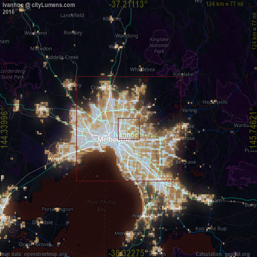
Analysis of Ivanhoe night lights 2016
Square area 10x10 km:
 21.26%
90-99
28.4%80-89
20.58%70-79
19.05%60-69
7.14%50-59
3.57%40-49
0%30-39
0%20-29
0%10-19
0%0-9
0%Square area 50x50 km:
14.12%90-99
12.94%80-89
6.62%70-79
9.46%60-69
7.91%50-59
5.05%40-49
3.76%30-39
3.14%20-29
5.71%10-19
7.87%0-9
23.42%Clear (daylight) street map image can be seen on geolist.org.
Map coordinates:
37° 12' 40.1" South, 144° 20' 23.9" East
37° 46' 8.5" South, 145° 2' 35.1" East
38° 19' 21.9" South, 145° 44' 46.4" East
Some cities around Ivanhoe sort by population:
• Preston
3.1 km =1.9 mi,  312°
312°
• Thornbury
3.5 km =2.2 mi,  290°
290°
• Bulleen
3.5 km =2.2 mi,  85°
85°
• Heidelberg
3 km =1.9 mi,  44°
44°
• Kew East
3.3 km =2.1 mi,  163°
163°
• Fairfield
2.5 km =1.6 mi,  241°
241°
• Heidelberg Heights
3.1 km =1.9 mi,  22°
22°
• Heidelberg West
3.3 km =2.1 mi,  355°
355°
8348012 (p: 12,175)
Sources (retrieved 2019-11-25):
» Earth at Night: Flat Maps 2012, 2016