Bulleen night lights from space
Night Light of Bulleen (Victoria) from space (Australia) Src. Average luminocity for 10x10km area is 78.6633% and for 50x50km: 50.3036%.
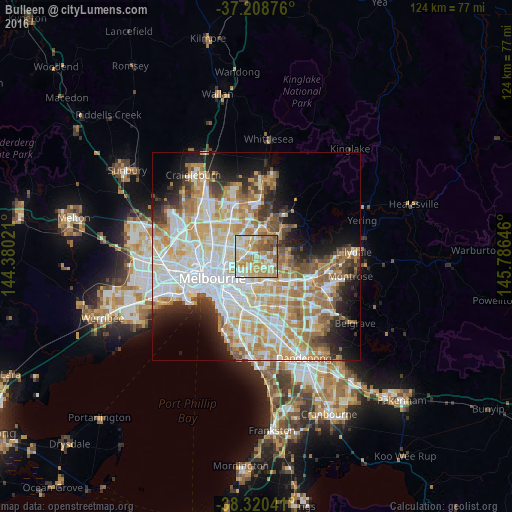
Analysis of Bulleen night lights 2016
Square area 10x10 km:
 10.71%
90-99
22.11%80-89
17.69%70-79
19.22%60-69
15.31%50-59
10.2%40-49
3.74%30-39
1.02%20-29
0%10-19
0%0-9
0%Square area 50x50 km:
13%90-99
12.13%80-89
6.22%70-79
9.17%60-69
7.61%50-59
4.87%40-49
3.74%30-39
3.4%20-29
5.73%10-19
8.4%0-9
25.74%Clear (daylight) street map image can be seen on geolist.org.
Map coordinates:
37° 12' 31.5" South, 144° 22' 48.8" East
37° 46' 0" South, 145° 4' 60" East
38° 19' 13.5" South, 145° 47' 11.3" East
Some cities around Bulleen sort by population:
• Balwyn North
2.8 km =1.7 mi,  161°
161°
• Templestowe Lower
2.9 km =1.8 mi,  90°
90°
• Ivanhoe
3.5 km =2.2 mi,  265°
265°
• Macleod
4 km =2.5 mi,  338°
338°
• Rosanna
3.4 km =2.1 mi, 335°
• Heidelberg
2.4 km =1.5 mi,  321°
321°
• Viewbank
3.1 km =1.9 mi,  16°
16°
• Heidelberg Heights
3.5 km =2.2 mi, 318°
2173464 (p: 10,756)
Sources (retrieved 2019-11-25):
» Earth at Night: Flat Maps 2012, 2016