Heidelberg Heights night lights from space
Night Light of Heidelberg Heights (Victoria) from space (Australia) Src. Average luminocity for 10x10km area is 82.2568% and for 50x50km: 50.1894%.
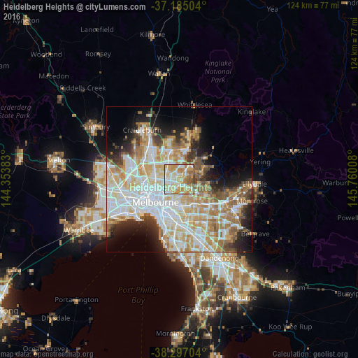
Analysis of Heidelberg Heights night lights 2016
Square area 10x10 km:
 14.12%
90-99
23.64%80-89
20.92%70-79
19.39%60-69
13.95%50-59
6.8%40-49
1.19%30-39
0%20-29
0%10-19
0%0-9
0%Square area 50x50 km:
13.59%90-99
12.18%80-89
6.33%70-79
8.62%60-69
7.17%50-59
4.78%40-49
3.74%30-39
3.33%20-29
5.6%10-19
7.9%0-9
26.75%Clear (daylight) street map image can be seen on geolist.org.
Map coordinates:
37° 11' 6.1" South, 144° 21' 13.8" East
37° 44' 35.3" South, 145° 3' 25" East
38° 17' 49.3" South, 145° 45' 36.3" East
Some cities around Heidelberg Heights sort by population:
• Preston
3.6 km =2.2 mi,  257°
257°
• Thornbury
4.8 km =3 mi,  249°
249°
• Ivanhoe
3.1 km =1.9 mi,  202°
202°
• Bulleen
3.5 km =2.2 mi,  138°
138°
• Macleod
1.4 km =0.9 mi,  38°
38°
• Rosanna
1 km =0.6 mi,  63°
63°
• Viewbank
3.2 km =2 mi,  83°
83°
• Watsonia
3.7 km =2.3 mi, 38°
9972412 (p: 6,010)
Sources (retrieved 2019-11-25):
» Earth at Night: Flat Maps 2012, 2016