Merrimac night lights from space
Night Light of Merrimac (Queensland) from space (Australia) Src. Average luminocity for 10x10km area is 69.2576% and for 50x50km: 15.9032%.
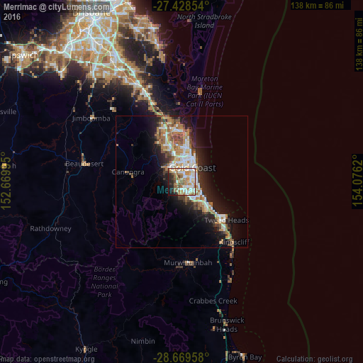
Analysis of Merrimac night lights 2016
Square area 10x10 km:
 15.91%
90-99
16.48%80-89
8.52%70-79
8.52%60-69
20.45%50-59
8.33%40-49
3.98%30-39
3.79%20-29
8.52%10-19
5.3%0-9
0.19%Square area 50x50 km:
2.79%90-99
2.97%80-89
1.51%70-79
1.26%60-69
4.48%50-59
1.69%40-49
1.85%30-39
1.9%20-29
3.84%10-19
8.76%0-9
68.96%Clear (daylight) street map image can be seen on geolist.org.
Map coordinates:
27° 25' 42.7" South, 152° 40' 11.8" East
28° 3' 3.1" South, 153° 22' 23.1" East
28° 40' 10.5" South, 154° 4' 34.3" East
Some cities around Merrimac sort by population:
• Robina
3 km =1.9 mi,  138°
138°
• Mudgeeraba
3.7 km =2.3 mi,  189°
189°
• Mermaid Waters
5.7 km =3.5 mi,  88°
88°
• Carrara
3.3 km =2.1 mi,  348°
348°
• Benowa
5 km =3.1 mi,  14°
14°
• Broadbeach Waters
5.4 km =3.4 mi,  70°
70°
• Highland Park
5.7 km =3.5 mi,  316°
316°
• Worongary
2.3 km =1.4 mi,  272°
272°
8348245 (p: 7,005)
Sources (retrieved 2019-11-25):
» Earth at Night: Flat Maps 2012, 2016