Macleod night lights from space
Night Light of Macleod (Victoria) from space (Australia) Src. Average luminocity for 10x10km area is 79.6071% and for 50x50km: 48.9175%.
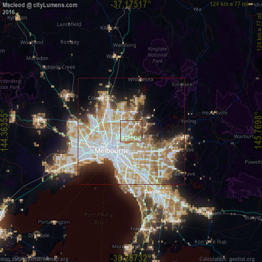
Analysis of Macleod night lights 2016
Square area 10x10 km:
 12.93%
90-99
21.43%80-89
18.03%70-79
17.86%60-69
16.67%50-59
9.86%40-49
2.89%30-39
0.34%20-29
0%10-19
0%0-9
0%Square area 50x50 km:
13.24%90-99
11.76%80-89
6.16%70-79
8.39%60-69
7.05%50-59
4.63%40-49
3.67%30-39
3.37%20-29
5.53%10-19
7.85%0-9
28.35%Clear (daylight) street map image can be seen on geolist.org.
Map coordinates:
37° 10' 30.6" South, 144° 21' 48.8" East
37° 43' 60" South, 145° 4' 0" East
38° 17' 14.4" South, 145° 46' 11.3" East
Some cities around Macleod sort by population:
• Bundoora
3.9 km =2.4 mi,  351°
351°
• Bulleen
4 km =2.5 mi,  158°
158°
• Rosanna
0.6 km =0.4 mi,  174°
174°
• Heidelberg
1.9 km =1.2 mi,  180°
180°
• Viewbank
2.4 km =1.5 mi,  107°
107°
• Heidelberg Heights
1.4 km =0.9 mi,  218°
218°
• Heidelberg West
2.4 km =1.5 mi,  254°
254°
• Watsonia
2.4 km =1.5 mi,  38°
38°
2159177 (p: 9,606)
Sources (retrieved 2019-11-25):
» Earth at Night: Flat Maps 2012, 2016