Watsonia night lights from space
Night Light of Watsonia (Victoria) from space (Australia) Src. Average luminocity for 10x10km area is 72.2024% and for 50x50km: 46.3619%.
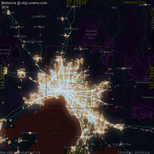
Analysis of Watsonia night lights 2016
Square area 10x10 km:
 9.35%
9.35%90-99
16.5%80-89
10.71%70-79
17.18%60-69
17.35%50-59
14.97%40-49
10.2%30-39
3.74%20-29
0%10-19
0%0-9
0%Square area 50x50 km:
12.38%90-99
11.14%80-89
5.81%70-79
7.98%60-69
6.72%50-59
4.52%40-49
3.54%30-39
3.28%20-29
5.19%10-19
7.57%0-9
31.88%Clear (daylight) street map image can be seen on geolist.org.
Map coordinates:
37° 9' 30.2" South, 144° 22' 48.8" East
37° 43' 0" South, 145° 4' 60" East
38° 16' 14.8" South, 145° 47' 11.3" East
Some cities around Watsonia sort by population:
• Bundoora
2.9 km =1.8 mi,  314°
314°
• Greensborough
2.2 km =1.4 mi,  52°
52°
• Macleod
2.4 km =1.5 mi,  218°
218°
• Montmorency
2.9 km =1.8 mi,  90°
90°
• Rosanna
2.8 km =1.7 mi,  209°
209°
• Heidelberg
4 km =2.5 mi,  201°
201°
• Viewbank
2.7 km =1.7 mi,  161°
161°
• Heidelberg Heights
3.7 km =2.3 mi, 218°
2144397 (p: 5,146)
Sources (retrieved 2019-11-25):
» Earth at Night: Flat Maps 2012, 2016