Healesville night lights from space
Night Light of Healesville (Victoria) from space (Australia) Src. Average luminocity for 10x10km area is 1.6276% and for 50x50km: 4.1543%.
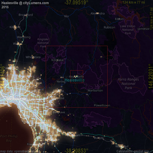
Analysis of Healesville night lights 2016
Square area 10x10 km:
 0%
0%90-99
0%80-89
0%70-79
0.68%60-69
0.68%50-59
0.34%40-49
0.34%30-39
0.68%20-29
0%10-19
0%0-9
97.28%Square area 50x50 km:
0.43%90-99
0.43%80-89
0.25%70-79
0.72%60-69
1.14%50-59
0.95%40-49
0.81%30-39
0.85%20-29
0.9%10-19
1.84%0-9
91.68%Clear (daylight) street map image can be seen on geolist.org.
Map coordinates:
37° 5' 42.7" South, 144° 48' 50.6" East
37° 39' 14.2" South, 145° 31' 1.8" East
38° 12' 30.7" South, 146° 13' 13.1" East
Some cities around Healesville sort by population:
• Croydon
26.2 km =16.3 mi,  231°
231°
• Mooroolbark
22.7 km =14.1 mi, 230°
• Lilydale
18.2 km =11.3 mi, 234°
• Kilsyth
24 km =14.9 mi, 227°
• Chirnside Park
20.2 km =12.6 mi,  242°
242°
• Mount Evelyn
18.6 km =11.6 mi,  219°
219°
• Croydon North
23.6 km =14.7 mi, 237°
• Montrose
23.3 km =14.5 mi, 219°
2163701 (p: 7,382)
Sources (retrieved 2019-11-25):
» Earth at Night: Flat Maps 2012, 2016