Brighton night lights from space
Night Light of Brighton (Queensland) from space (Australia) Src. Average luminocity for 10x10km area is 55.5852% and for 50x50km: 29.4706%.
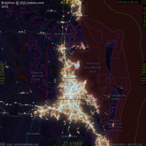
Analysis of Brighton night lights 2016
Square area 10x10 km:
 6.44%
6.44%90-99
7.95%80-89
7.39%70-79
7.2%60-69
21.4%50-59
6.44%40-49
9.47%30-39
9.47%20-29
17.99%10-19
6.25%0-9
0%Square area 50x50 km:
5.67%90-99
6.25%80-89
3.71%70-79
3.31%60-69
7.78%50-59
2.4%40-49
3.21%30-39
3.26%20-29
4.96%10-19
9.33%0-9
50.14%Clear (daylight) street map image can be seen on geolist.org.
Map coordinates:
26° 40' 9.3" South, 152° 21' 14.7" East
27° 17' 45" South, 153° 3' 26" East
27° 55' 8" South, 153° 45' 37.2" East
Some cities around Brighton sort by population:
• Bracken Ridge
3.5 km =2.2 mi,  227°
227°
• Murrumba Downs
5.6 km =3.5 mi,  304°
304°
• Boondall
6.4 km =4 mi,  176°
176°
• Clontarf
5.2 km =3.2 mi,  23°
23°
• Griffin
3.2 km =2 mi,  326°
326°
• Taigum
5.4 km =3.4 mi,  193°
193°
• Bald Hills
5.6 km =3.5 mi,  239°
239°
• Fitzgibbon
5.6 km =3.5 mi,  209°
209°
2174040 (p: 9,361)
Sources (retrieved 2019-11-25):
» Earth at Night: Flat Maps 2012, 2016