Greenwith night lights from space
Night Light of Greenwith (South Australia) from space (Australia) Src. Average luminocity for 10x10km area is 44.9927% and for 50x50km: 24.1638%.
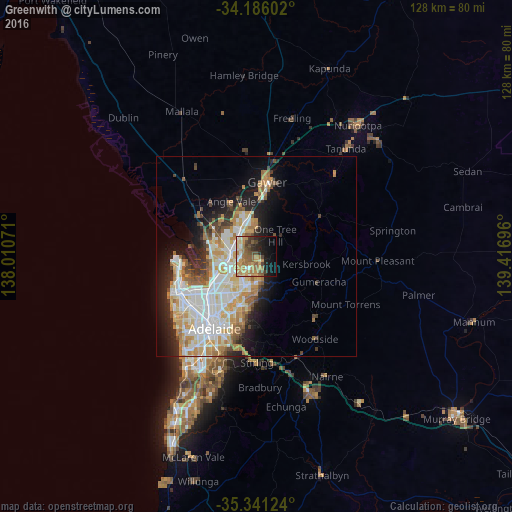
Analysis of Greenwith night lights 2016
Square area 10x10 km:
 2.93%
2.93%90-99
4.4%80-89
5.49%70-79
14.1%60-69
12.27%50-59
9.71%40-49
6.04%30-39
5.13%20-29
8.06%10-19
17.22%0-9
14.65%Square area 50x50 km:
5.49%90-99
5.69%80-89
2.69%70-79
4.5%60-69
3.26%50-59
2.52%40-49
1.81%30-39
1.9%20-29
4%10-19
7.78%0-9
60.35%Clear (daylight) street map image can be seen on geolist.org.
Map coordinates:
34° 11' 9.7" South, 138° 0' 38.6" East
34° 45' 56.3" South, 138° 42' 49.8" East
35° 20' 28.5" South, 139° 25' 1.1" East
Some cities around Greenwith sort by population:
• Craigmore
7.2 km =4.5 mi,  356°
356°
• Golden Grove
2.7 km =1.7 mi,  137°
137°
• Salisbury East
6.1 km =3.8 mi,  242°
242°
• Wynn Vale
4.5 km =2.8 mi,  212°
212°
• Modbury Heights
5.5 km =3.4 mi, 207°
• Para Hills
7.3 km =4.5 mi,  224°
224°
• Redwood Park
5.1 km =3.2 mi,  187°
187°
• Salisbury Heights
3.5 km =2.2 mi,  274°
274°
8348988 (p: 8,763)
Sources (retrieved 2019-11-25):
» Earth at Night: Flat Maps 2012, 2016