Craigmore night lights from space
Night Light of Craigmore (South Australia) from space (Australia) Src. Average luminocity for 10x10km area is 45.3168% and for 50x50km: 20.1018%.
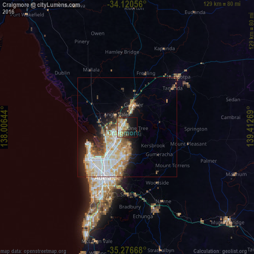
Analysis of Craigmore night lights 2016
Square area 10x10 km:
 5.86%
5.86%90-99
10.44%80-89
6.96%70-79
10.07%60-69
6.78%50-59
4.21%40-49
3.48%30-39
4.03%20-29
10.81%10-19
20.51%0-9
16.85%Square area 50x50 km:
4.35%90-99
4.79%80-89
2.34%70-79
3.52%60-69
2.63%50-59
2.14%40-49
1.6%30-39
1.93%20-29
3.28%10-19
6.8%0-9
66.63%Clear (daylight) street map image can be seen on geolist.org.
Map coordinates:
34° 7' 14" South, 138° 0' 23.2" East
34° 42' 2.3" South, 138° 42' 34.4" East
35° 16' 36" South, 139° 24' 45.7" East
Some cities around Craigmore sort by population:
• Golden Grove
9.4 km =5.8 mi,  166°
166°
• Greenwith
7.2 km =4.5 mi,  176°
176°
• Andrews Farm
5.1 km =3.2 mi,  301°
301°
• Blakeview
2.8 km =1.7 mi,  1°
1°
• Davoren Park
3.9 km =2.4 mi,  286°
286°
• Munno Para West
4.8 km =3 mi,  326°
326°
• Salisbury Heights
7.6 km =4.7 mi,  203°
203°
• Elizabeth Downs
1.7 km =1.1 mi,  273°
273°
8347802 (p: 10,745)
Sources (retrieved 2019-11-25):
» Earth at Night: Flat Maps 2012, 2016