Gisborne night lights from space
Night Light of Gisborne (Victoria) from space (Australia) Src. Average luminocity for 10x10km area is 3.2955% and for 50x50km: 5.9675%.
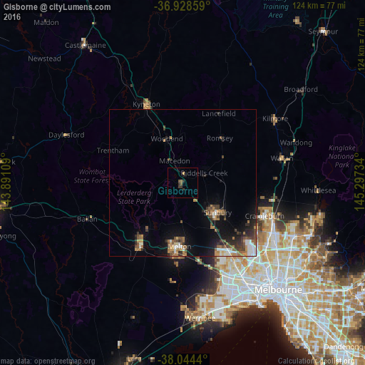
Analysis of Gisborne night lights 2016
Square area 10x10 km:
 0%
0%90-99
0%80-89
0%70-79
0.65%60-69
0.49%50-59
1.14%40-49
0.32%30-39
2.76%20-29
0.49%10-19
1.3%0-9
92.86%Square area 50x50 km:
0.75%90-99
0.71%80-89
0.2%70-79
0.89%60-69
1.14%50-59
1.07%40-49
1.12%30-39
1.01%20-29
1.61%10-19
3.72%0-9
87.79%Clear (daylight) street map image can be seen on geolist.org.
Map coordinates:
36° 55' 42.9" South, 143° 53' 27.9" East
37° 29' 18.9" South, 144° 35' 39.2" East
38° 2' 39.8" South, 145° 17' 50.4" East
Some cities around Gisborne sort by population:
• Sunbury
15.3 km =9.5 mi,  130°
130°
• Melton West
21.2 km =13.2 mi,  186°
186°
• Melton South
24.4 km =15.2 mi,  183°
183°
• Kurunjang
20.8 km =12.9 mi, 179°
• Brookfield
23.8 km =14.8 mi, 187°
• Darley
23.1 km =14.4 mi,  215°
215°
• Melton
21.7 km =13.5 mi, 182°
• Woodend
16 km =9.9 mi,  338°
338°
2165488 (p: 8,725)
Sources (retrieved 2019-11-25):
» Earth at Night: Flat Maps 2012, 2016