Kurunjang night lights from space
Night Light of Kurunjang (Victoria) from space (Australia) Src. Average luminocity for 10x10km area is 29.5408% and for 50x50km: 19.0737%.
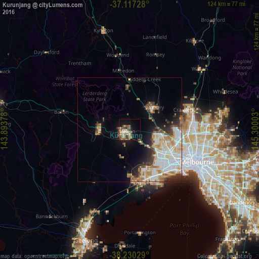
Analysis of Kurunjang night lights 2016
Square area 10x10 km:
 3.57%
3.57%90-99
2.55%80-89
2.04%70-79
6.12%60-69
6.97%50-59
7.65%40-49
5.95%30-39
1.87%20-29
2.89%10-19
19.39%0-9
40.99%Square area 50x50 km:
4.6%90-99
4.33%80-89
1.84%70-79
2.65%60-69
2.65%50-59
2.06%40-49
1.82%30-39
1.88%20-29
3.09%10-19
6.06%0-9
69.02%Clear (daylight) street map image can be seen on geolist.org.
Map coordinates:
37° 7' 2.2" South, 143° 53' 37.6" East
37° 40' 33.1" South, 144° 35' 48.8" East
38° 13' 49" South, 145° 18' 0.1" East
Some cities around Kurunjang sort by population:
• Caroline Springs
14.3 km =8.9 mi,  120°
120°
• Melton West
2.5 km =1.6 mi,  263°
263°
• Hillside
12.8 km =8 mi,  97°
97°
• Melton South
4 km =2.5 mi,  208°
208°
• Brookfield
4.3 km =2.7 mi,  229°
229°
• Darley
13.7 km =8.5 mi,  278°
278°
• Melton
1.3 km =0.8 mi, 230°
• Bacchus Marsh
14 km =8.7 mi,  271°
271°
7932575 (p: 9,997)
Sources (retrieved 2019-11-25):
» Earth at Night: Flat Maps 2012, 2016