Melton South night lights from space
Night Light of Melton South (Victoria) from space (Australia) Src. Average luminocity for 10x10km area is 32.0629% and for 50x50km: 18.1728%.
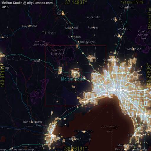
Analysis of Melton South night lights 2016
Square area 10x10 km:
 3.57%
3.57%90-99
2.55%80-89
1.36%70-79
7.14%60-69
8.33%50-59
7.48%40-49
6.29%30-39
2.55%20-29
3.57%10-19
28.57%0-9
28.57%Square area 50x50 km:
4.05%90-99
3.77%80-89
1.65%70-79
2.67%60-69
2.77%50-59
2.27%40-49
1.86%30-39
1.9%20-29
3.38%10-19
6.4%0-9
69.28%Clear (daylight) street map image can be seen on geolist.org.
Map coordinates:
37° 8' 57.7" South, 143° 52' 18.5" East
37° 42' 27.8" South, 144° 34' 29.7" East
38° 15' 42.9" South, 145° 16' 41" East
Some cities around Melton South sort by population:
• Caroline Springs
14.7 km =9.1 mi,  104°
104°
• Hillside
14.8 km =9.2 mi,  82°
82°
• Taylors Hill
15.8 km =9.8 mi,  90°
90°
• Kurunjang
4 km =2.5 mi,  28°
28°
• Brookfield
1.5 km =0.9 mi,  300°
300°
• Darley
12.8 km =8 mi, 295°
• Bacchus Marsh
12.6 km =7.8 mi,  287°
287°
• Burnside Heights
15.7 km =9.8 mi, 97°
2158145 (p: 11,426)
Sources (retrieved 2019-11-25):
» Earth at Night: Flat Maps 2012, 2016