Melton West night lights from space
Night Light of Melton West (Victoria) from space (Australia) Src. Average luminocity for 10x10km area is 32.7075% and for 50x50km: 16.7566%.
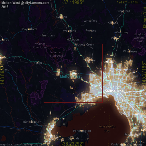
Analysis of Melton West night lights 2016
Square area 10x10 km:
 3.57%
3.57%90-99
2.55%80-89
2.04%70-79
7.14%60-69
7.65%50-59
8.5%40-49
6.63%30-39
2.55%20-29
3.57%10-19
28.4%0-9
27.38%Square area 50x50 km:
3.83%90-99
3.52%80-89
1.51%70-79
2.48%60-69
2.58%50-59
2.09%40-49
1.66%30-39
1.64%20-29
2.74%10-19
5.62%0-9
72.33%Clear (daylight) street map image can be seen on geolist.org.
Map coordinates:
37° 7' 11.8" South, 143° 51' 56.6" East
37° 40' 42.7" South, 144° 34' 7.8" East
38° 13' 58.5" South, 145° 16' 19.1" East
Some cities around Melton West sort by population:
• Caroline Springs
16.3 km =10.1 mi,  115°
115°
• Hillside
15.3 km =9.5 mi,  94°
94°
• Taylors Hill
16.7 km =10.4 mi,  102°
102°
• Kurunjang
2.5 km =1.6 mi,  83°
83°
• Brookfield
2.6 km =1.6 mi,  196°
196°
• Darley
11.3 km =7 mi,  281°
281°
• Bacchus Marsh
11.5 km =7.1 mi,  273°
273°
• Burnside Heights
17 km =10.6 mi,  108°
108°
7932573 (p: 17,477)
Sources (retrieved 2019-11-25):
» Earth at Night: Flat Maps 2012, 2016