Brookfield night lights from space
Night Light of Brookfield (Victoria) from space (Australia) Src. Average luminocity for 10x10km area is 33.4813% and for 50x50km: 16.897%.
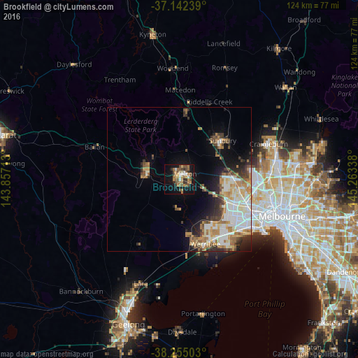
Analysis of Brookfield night lights 2016
Square area 10x10 km:
 3.57%
3.57%90-99
2.55%80-89
2.04%70-79
7.14%60-69
8.67%50-59
8.5%40-49
7.31%30-39
2.55%20-29
3.57%10-19
28.4%0-9
25.68%Square area 50x50 km:
3.6%90-99
3.37%80-89
1.57%70-79
2.58%60-69
2.74%50-59
2.25%40-49
1.79%30-39
1.83%20-29
2.83%10-19
6%0-9
71.44%Clear (daylight) street map image can be seen on geolist.org.
Map coordinates:
37° 8' 32.6" South, 143° 51' 25.7" East
37° 42' 2.9" South, 144° 33' 36.9" East
38° 15' 18.1" South, 145° 15' 48.2" East
Some cities around Brookfield sort by population:
• Caroline Springs
16.1 km =10 mi,  106°
106°
• Melton West
2.6 km =1.6 mi,  16°
16°
• Hillside
16 km =9.9 mi,  85°
85°
• Melton South
1.5 km =0.9 mi,  120°
120°
• Kurunjang
4.3 km =2.7 mi,  49°
49°
• Darley
11.3 km =7 mi,  294°
294°
• Melton
2.9 km =1.8 mi, 48°
• Bacchus Marsh
11.2 km =7 mi, 286°
7932574 (p: 9,145)
Sources (retrieved 2019-11-25):
» Earth at Night: Flat Maps 2012, 2016