Fulham Gardens night lights from space
Night Light of Fulham Gardens (South Australia) from space (Australia) Src. Average luminocity for 10x10km area is 68.2821% and for 50x50km: 26.7207%.
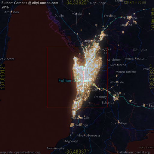
Analysis of Fulham Gardens night lights 2016
Square area 10x10 km:
 16.85%
90-99
20.51%80-89
11.36%70-79
14.84%60-69
5.86%50-59
1.47%40-49
2.2%30-39
2.01%20-29
13.19%10-19
10.81%0-9
0.92%Square area 50x50 km:
5.81%90-99
6.05%80-89
2.75%70-79
4.89%60-69
4.14%50-59
3.51%40-49
2.56%30-39
2.02%20-29
4.38%10-19
7.87%0-9
56.01%Clear (daylight) street map image can be seen on geolist.org.
Map coordinates:
34° 20' 10.5" South, 137° 48' 36.4" East
34° 54' 53.4" South, 138° 30' 47.7" East
35° 29' 21.7" South, 139° 12' 58.9" East
Some cities around Fulham Gardens sort by population:
• Seaton
1.7 km =1.1 mi,  10°
10°
• North Adelaide
7.2 km =4.5 mi,  83°
83°
• Findon
2.5 km =1.6 mi,  48°
48°
• Glenelg North
5.9 km =3.7 mi,  176°
176°
• Henley Beach
1.8 km =1.1 mi,  250°
250°
• Grange
2.5 km =1.6 mi,  303°
303°
• West Lakes
5 km =3.1 mi,  339°
339°
• Lockleys
1.8 km =1.1 mi,  132°
132°
8348985 (p: 6,056)
Sources (retrieved 2019-11-25):
» Earth at Night: Flat Maps 2012, 2016